Images and satellite products and weather radar images.
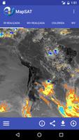
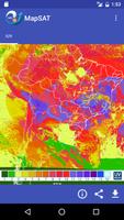
The application allows the visualization of the latest processed images from meteorological satellites to the infrared and visible water vapor channels in simple and highlighted images format with Latin American coverage. In addition, some products derived from satellite data are available, such as ultraviolet index (UVI), sea surface temperature and sea surface wind.
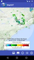
To monitor areas with potential for precipitation, the MapSAT application provides the latest meteorological radar images scattered throughout the national territory, belonging to the DECEA / Redemet, Cemaden, INEA and Ipmet / Unesp network.
For most maps, you can view animations with up to 24 images.
In the lower bar of each map view, the user has resources for sharing, downloading the image, product animation and informational text with technical details about the product being viewed.
This app makes use of the Google Maps Android API to view the maps in the Radars functionality.
Google's terms of service and Google's privacy policy are available on the links:
https://www.google.com/intl/en/policies/terms/
https://www.google.com/policies/privacy/
See our Privacy Policy, available at http://satelite.cptec.inpe.br/repositorio9/documentos/apps/politica_privacidade_apps_cptec.pdf
Get free Primogems, Mora, Experience, and more with these November 2024 Genshin Impact codes, 5.1 livestream codes, and find out how to redeem active codes.
If you are bored with playing the vanilla version of Metaphor ReFantazio, you can check out these five mods.
Struggling with your submissions for Roblox's The Haunt event in 2024? Check out our guide on using Dress to Impress to create your captures!
Our walkthrough for Dragon Age: The Veilguard with some handy tips and tricks, with guides for puzzles, bosses, companions, equipment, romance, and more!
Which faction should you pick in Dragon Age: The Veilguard?
Looking for some bonus resources in Sea of Conquest: Pirate War? We’ve got you covered with these codes for the latest seafaring freebies.